Difference between revisions of "File:Solar Irradiation ET.jpg"
From energypedia
***** (***** | *****) |
***** (***** | *****) |
||
| Line 2: | Line 2: | ||
Solar irradiation in Ethiopia (in kWh/m2/day). Source: modified SWERA 2005. Solar, annual average latitude tilt map at 40km resolution for Africa from NREL http://swera.unep.net/typo3conf/ext/metadata_tool/archive/download/africatilt_218.pdf | Solar irradiation in Ethiopia (in kWh/m2/day). Source: modified SWERA 2005. Solar, annual average latitude tilt map at 40km resolution for Africa from NREL http://swera.unep.net/typo3conf/ext/metadata_tool/archive/download/africatilt_218.pdf | ||
| + | |||
| + | == Licensing == | ||
| + | {{Template:License_box_template| | ||
| + | '''External file, license unclear.'''|This file is from an '''external source''', the '''usage rights are unclear'''. <br />Only for internal use.|}} | ||
| + | |||
| + | [[Category:License Template]] | ||
| + | |||
[[Category:Ethiopia]] | [[Category:Ethiopia]] | ||
| − | |||
| − | |||
| − | |||
Revision as of 11:24, 22 August 2011
Summary
Solar irradiation in Ethiopia (in kWh/m2/day). Source: modified SWERA 2005. Solar, annual average latitude tilt map at 40km resolution for Africa from NREL http://swera.unep.net/typo3conf/ext/metadata_tool/archive/download/africatilt_218.pdf
Licensing
File history
Click on a date/time to view the file as it appeared at that time.
| Date/Time | Thumbnail | Dimensions | User | Comment | |
|---|---|---|---|---|---|
| current | 11:27, 22 August 2011 | 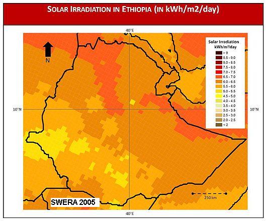 | 531 × 440 (49 KB) | ***** (***** | *****) | |
| 12:26, 11 July 2011 | 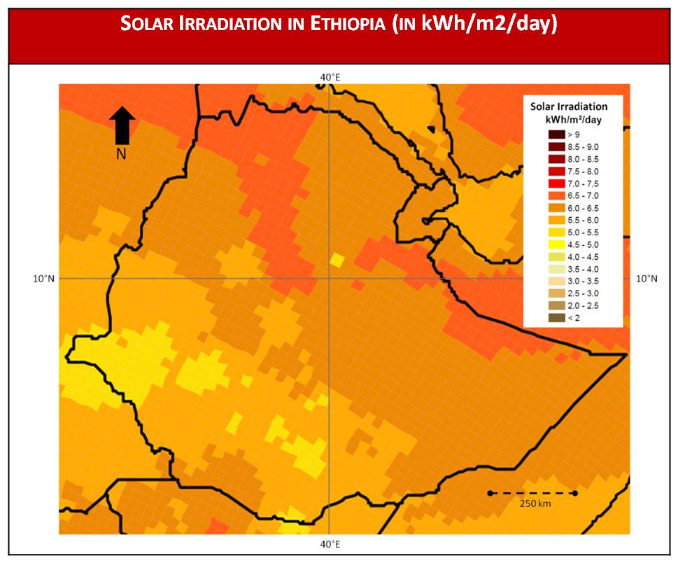 | 969 × 804 (89 KB) | ***** (***** | *****) | Solar irradiation in Ethiopia (in kWh/m2/day). Source: SWERA 2005. Solar, annual average latitude tilt map at 40km resolution for Africa from NREL http://swera.unep.net/typo3conf/ext/metadata_tool/archive/download/africatilt_218.pdf [[Category:Ethiopia |
You cannot overwrite this file.
File usage
The following page uses this file:


