Difference between revisions of "File:Location Morocco.png"
***** (***** | *****) (English: Locator of Morocco and it's disputed territory Western Sahara shown as striped. United Nations recognize Morocco as an administrative power of the territory. Description Morocco (orthographic projection).svg "The Secretary-General shared the vi) |
***** (***** | *****) |
||
| Line 1: | Line 1: | ||
| − | English: Locator of Morocco and it's disputed territory Western Sahara shown as striped. United Nations recognize Morocco as an administrative power of the territory. | + | English: Locator of Morocco and it's disputed territory Western Sahara shown as striped. United Nations recognize Morocco as an administrative power of the territory. |
| − | Description Morocco (orthographic projection).svg | + | Description Morocco (orthographic projection).svg |
| − | "The Secretary-General shared the view of his Personal Envoy that further meetings of the parties would not succeed, and could indeed be counterproductive, unless the Government of Morocco, as administrative power of the Territory, was prepared to offer or support some devolution of authority" Report of the Secretary-General of the United Nations] Date | + | "The Secretary-General shared the view of his Personal Envoy that further meetings of the parties would not succeed, and could indeed be counterproductive, unless the Government of Morocco, as administrative power of the Territory, was prepared to offer or support some devolution of authority" Report of the Secretary-General of the United Nations] Date |
| − | January 2010(2010-01) Source | + | January 2010(2010-01) Source |
| − | Own work GNU head Permission is granted to copy, distribute and/or modify this map under the terms of the GNU Free Documentation License, Version 1.2 or any later version published by the Free Software Foundation; with no Invariant Sections, no Front-Cover Texts, and no Back-Cover Texts. A copy of the license is included in the section entitled "GNU Free Documentation License". | + | Own work GNU head Permission is granted to copy, distribute and/or modify this map under the terms of the GNU Free Documentation License, Version 1.2 or any later version published by the Free Software Foundation; with no Invariant Sections, no Front-Cover Texts, and no Back-Cover Texts. A copy of the license is included in the section entitled "GNU Free Documentation License". |
| − | The map has been created with the Generic Mapping Tools: http://gmt.soest.hawaii.edu/ using one or more of these public domain datasets for the relief: | + | The map has been created with the Generic Mapping Tools: http://gmt.soest.hawaii.edu/ using one or more of these public domain datasets for the relief: |
* ETOPO2 (topography/bathymetry): http://www.ngdc.noaa.gov/mgg/global/global.html | * ETOPO2 (topography/bathymetry): http://www.ngdc.noaa.gov/mgg/global/global.html | ||
| Line 15: | Line 15: | ||
* SRTM (topography): http://www2.jpl.nasa.gov/srtm/ | * SRTM (topography): http://www2.jpl.nasa.gov/srtm/ | ||
| − | Permission is granted to copy, distribute and/or modify this document under the terms of the GNU Free Documentation License, Version 1.2 or any later version published by the Free Software Foundation; with no Invariant Sections, no Front-Cover Texts, and no Back-Cover Texts. A copy of the license is included in the section entitled GNU Free Documentation License. | + | Permission is granted to copy, distribute and/or modify this document under the terms of the GNU Free Documentation License, Version 1.2 or any later version published by the Free Software Foundation; with no Invariant Sections, no Front-Cover Texts, and no Back-Cover Texts. A copy of the license is included in the section entitled GNU Free Documentation License. |
| − | http://www.gnu.org/copyleft/fdl.htmlGFDLGNU Free Documentation Licensetruetrue w:en:Creative Commons attribution share alike This file is licensed under the Creative Commons Attribution-Share Alike 3.0 Unported license. | + | http://www.gnu.org/copyleft/fdl.htmlGFDLGNU Free Documentation Licensetruetrue w:en:Creative Commons attribution share alike This file is licensed under the Creative Commons Attribution-Share Alike 3.0 Unported license. |
You are free: | You are free: | ||
| Line 29: | Line 29: | ||
* share alike – If you alter, transform, or build upon this work, you may distribute the resulting work only under the same or similar license to this one. | * share alike – If you alter, transform, or build upon this work, you may distribute the resulting work only under the same or similar license to this one. | ||
| − | This licensing tag was added to this file as part of the GFDL licensing update. | + | This licensing tag was added to this file as part of the GFDL licensing update. Edit section: Licensing Licensing |
| − | Edit section: Licensing Licensing | ||
| − | External file, Open Content. | + | External file, Open Content. This file is from an external source. It has been published under an open content license. Details about the license can be found in the file description. |
| − | + | ||
| − | Details about the license can be found in the file description. | + | [[Category:Morocco]][[Category:Systemfile]] |
| − | [[Category:Morocco]] | ||
Revision as of 13:30, 9 June 2011
English: Locator of Morocco and it's disputed territory Western Sahara shown as striped. United Nations recognize Morocco as an administrative power of the territory.
Description Morocco (orthographic projection).svg
"The Secretary-General shared the view of his Personal Envoy that further meetings of the parties would not succeed, and could indeed be counterproductive, unless the Government of Morocco, as administrative power of the Territory, was prepared to offer or support some devolution of authority" Report of the Secretary-General of the United Nations] Date
January 2010(2010-01) Source
Own work GNU head Permission is granted to copy, distribute and/or modify this map under the terms of the GNU Free Documentation License, Version 1.2 or any later version published by the Free Software Foundation; with no Invariant Sections, no Front-Cover Texts, and no Back-Cover Texts. A copy of the license is included in the section entitled "GNU Free Documentation License".
The map has been created with the Generic Mapping Tools: http://gmt.soest.hawaii.edu/ using one or more of these public domain datasets for the relief:
  * ETOPO2 (topography/bathymetry): http://www.ngdc.noaa.gov/mgg/global/global.html
  * GLOBE (topography): http://www.ngdc.noaa.gov/mgg/topo/globe.html
  * SRTM (topography): http://www2.jpl.nasa.gov/srtm/
Permission is granted to copy, distribute and/or modify this document under the terms of the GNU Free Documentation License, Version 1.2 or any later version published by the Free Software Foundation; with no Invariant Sections, no Front-Cover Texts, and no Back-Cover Texts. A copy of the license is included in the section entitled GNU Free Documentation License.
http://www.gnu.org/copyleft/fdl.htmlGFDLGNU Free Documentation Licensetruetrue w:en:Creative Commons attribution share alike This file is licensed under the Creative Commons Attribution-Share Alike 3.0 Unported license.
You are free:
      * to share – to copy, distribute and transmit the work
      * to remix – to adapt the work
Under the following conditions:
      * attribution – You must attribute the work in the manner specified by the author or licensor (but not in any way that suggests that they endorse you or your use of the work).
      * share alike – If you alter, transform, or build upon this work, you may distribute the resulting work only under the same or similar license to this one.
This licensing tag was added to this file as part of the GFDL licensing update. Edit section: Licensing Licensing
External file, Open Content. This file is from an external source. It has been published under an open content license. Details about the license can be found in the file description.
File history
Click on a date/time to view the file as it appeared at that time.
| Date/Time | Thumbnail | Dimensions | User | Comment | |
|---|---|---|---|---|---|
| current | 12:00, 17 March 2011 | 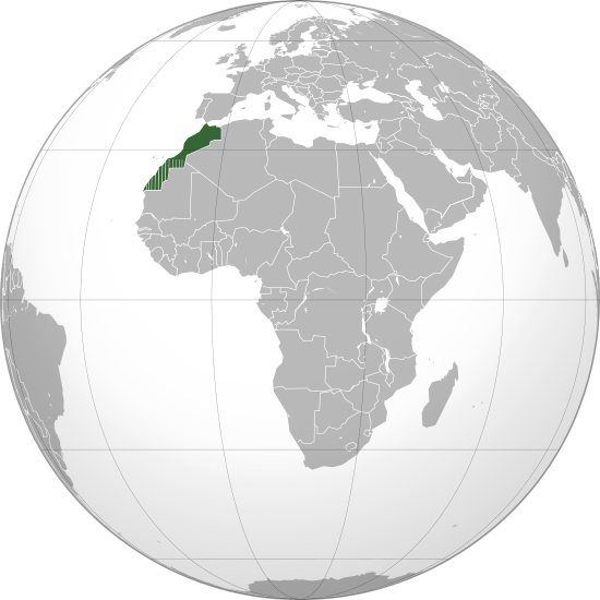 | 550 × 550 (110 KB) | ***** (***** | *****) | English: Locator of Morocco and it's disputed territory Western Sahara shown as striped. United Nations recognize Morocco as an administrative power of the territory. Description Morocco (orthographic projection).svg "The Secretary-General shared the vi |
You cannot overwrite this file.
File usage
The following page uses this file:


