Difference between revisions of "Tajikistan Energy Situation"
***** (***** | *****) |
***** (***** | *****) |
||
| Line 65: | Line 65: | ||
= Geography and Climatic Conditions = | = Geography and Climatic Conditions = | ||
| − | Tajikistan is Central Asia's smallest country. It is landlocked and lies | + | Tajikistan is Central Asia's smallest country. It is landlocked and lies in the active seismic zone with frequent earthquakes. Mountains and territory over 3000m covers 93% of its area, with the the Pamir and Alay Mountains dominating the landscape.<ref name="CIA">CIA - The World Factbook</ref> |
<br> | <br> | ||
| − | Tajikistan | + | Tajikistan<span id="fck_dom_range_temp_1323783560528_63" /><span id="fck_dom_range_temp_1323783560528_42" />'s climate is continental with seasonal variations. It has hot summers and mild winters and a semiarid to polar climate in Pamir Mountains. The average low and high temperatures are 8.1°C and 22.0 °C, respectively. <ref name="CIA">CIA - The World Factbook</ref> |
<br> | <br> | ||
Revision as of 13:15, 15 December 2011
| Tajikistan | |||
| |
| ||
| Capital | Dushanbe (38° 33′ 0″ N, 68° 48′ 0″ E) | ||
| Official Language(s) | Persian (Tajik) | ||
| Government | Unitary semi-presidential republic | ||
| President | Emomalii Rahmon | ||
| Prime Minister | Oqil Oqilov | ||
| Total Area |
143,100 km2 | ||
| Total Population | 7.6 million | ||
| Urban-Population | 2 million (26%) | ||
| Rural-Population | 5.6 million (74%) | ||
| Population Density | 48 Persons per km² | ||
| Average Household Size | 6.3 | ||
| GDP (nominal) | |||
| GDP per Capita | $362.00 | ||
| GNI per Capita | $ 468.00 | ||
| Currency | Somoni (TJS) | ||
| Time Zone | TJT (UTC+5) | ||
| Calling Code | +992 | ||
Geography and Climatic Conditions
Tajikistan is Central Asia's smallest country. It is landlocked and lies in the active seismic zone with frequent earthquakes. Mountains and territory over 3000m covers 93% of its area, with the the Pamir and Alay Mountains dominating the landscape.[1]
Tajikistan<span id="fck_dom_range_temp_1323783560528_63" /><span id="fck_dom_range_temp_1323783560528_42" />'s climate is continental with seasonal variations. It has hot summers and mild winters and a semiarid to polar climate in Pamir Mountains. The average low and high temperatures are 8.1°C and 22.0 °C, respectively. [1]
2.9% of the land in Tajikistan is covered by forest. The forest annual rate of change (between 2005-2010) was 0% [2]
Socio-economic Situation
Tajikistan has a population of 7.6 million, the majority of which (74%), lives in rural areas. The population density is 48 Persons per km² .
Tajikistan is the poorest country in Central Asia and its economy remains fragile due to corruption, weak governance, unemployment, and seasonal power shortages. Yet recent years have seen an annual economic growth rate of 8-10%. The current GDP is ____ and GDP per capita is ___. Its economy is based on the production of hydro power, cotton, and aluminum and national income sources consist primarily of agriculture (49.8%), services (37.4%), and industry (12.8%). [1]
More than 40% of the populations lives under the poverty line of 2 USD/day.
National Energy Situation
Tajikistan has enormous hydro power potential as it possesses 4% of the world's hydro power resources and 53% of Central Asia's resources. Yet these resources remain to be sufficiently developed. About 94% of electricity generating capacity is hydroelectric, but only an estimated 5% of its potential is in use.
The country faces an energy deficit of 3.0 to 3.5 GWh, resulting in regular blackouts from October to April.
Primary energy shares in 2008 consisted of the following: 21.6% oil, 18.3% gas, 56.4% hydro, and coal 3.7%.
The electrification rate is 85.4%[3]. Hydro-electricelectricity generates around 17,00GWh per year. Prices vary but people typically pay 1.5 US cents/kWh. The TajikAluminum Company (TALCO), is the largest consumer in Tajikistan and uses about 50% of total electricity consumption.
Many components if the transmission and distrribution system are in bad condition and need to be replaced. Network and commerical losses result in up to 17'% losses. Rural populations experience more difficulties in accessing electric power due to bad conditions of the system, instability of voltage, and high losses.
Potential for Renewable Energies
Since electricity prices are very low due to low prime costs for the large hydro plants, alternative ways to generate electricity have been limited. Tajikistan's rivers have great hydropower potential and thus, the government has focused on attracting investments for projects for internal use and electricity exports. [4] furthermore, hydro-power is the only RE source for electricity production on national level, whose input is documented. [5]
However, the estimated solar potential is about 25 billion kWh/year in Tajikistan. There are about 2,100 to 3,000 hours of solar energy per year. While this potential has not yet been exploited, Tajikistan does utilize some solar resources for water heating purposes.[6]
Household Energy Situation
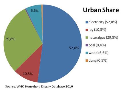
Share of energy types on cooking energy in urban areas of Tajikistan.[7]
Share of energy types on cooking energy in urban areas of Tajikistan.[7]
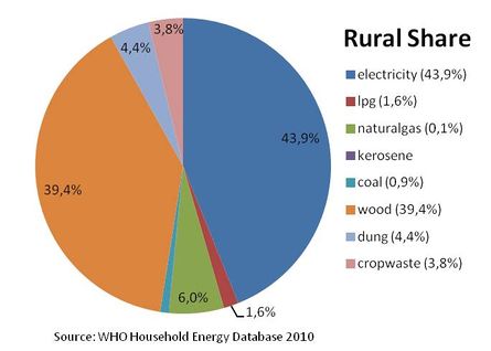
Percentage of population using solid fuels (charcoal, coal, cropwaste, dung and wood) as cooking energy.
National: 21.5%, urban:<5%, rural: 34.5% [7]
Solid Fuel Use Impact on Health
Total annual deaths attributable to solid fuel use: 1600 persons
Percentage of national burden of diseases attributable to solid fuel use: 3.5%[8]
Policy framework, laws and regulations
Market Risks
Relevant institutions and organisations
Existing projects
References
- ↑ 1.0 1.1 1.2 CIA - The World Factbook
- ↑ FAO (2011): The State of the World's Forest
- ↑ http://www.ngdc.noaa.gov/dmsp/pubs/Elvidge_WINTD_20091022.pdf
- ↑ INOGATE Energy Portal
- ↑ http://www.iea.org/stats/renewdata.asp?COUNTRY_CODE=KG
- ↑ INOGATE Energy Portal
- ↑ 7.0 7.1 7.2 WHO 2010: WHO Household Energy Database
- ↑ WHO (2006): Fuel for Life - Household Energy and Health


